ALABAMA'S MOST BEAUTIFUL PLACES
Little River Canyon
By Frank Emory Click
any image for a full size tour
DeSoto Falls
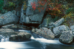
The Canyon below DeSoto Falls
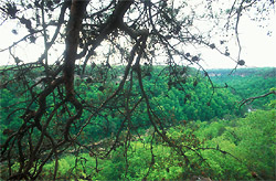
Little River Canyon rim
DeSoto Falls
Laurel Creek - DeSoto State Park
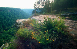
Along the rim of Little River Canyon
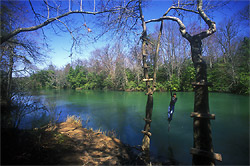
"Blue Hole" on Little River
Brooks Branch enter Little River
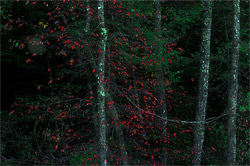
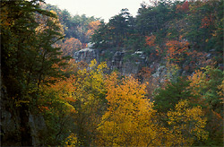
Fall foilage along Canyon Rim Drive
Little River
Little River Canyon
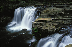
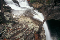
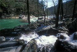
Little River Falls
Wolf Creek
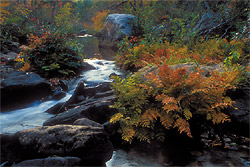
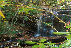
Brooks Branch
Little River Canyon
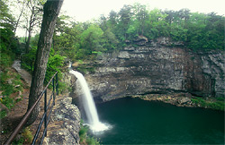
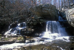
DeSoto Falls
In the northeastern corner of Alabama on Lookout Mountain,
near the town of Mentone, in DeSoto State Park, you find the
most magnificent waterfall in Alabama, DeSoto Falls.
Dropping 104 feet into the west fork of Little River, these
pristine headwaters meander a few miles downstream to find
their way into the heart of Little River Canyon.
Just above the falls stands a twenty-foot high dam, built in
the 1920's by a brilliant, self-educated electrical
engineer, Arthur Abernathy Miller. It was created to help
supply power for his hydroelectric generator which was
constructed below the falls. Today, if you cross the dam and
take the trail down to the site, you find remnants of the
concrete base where power was generated to supply the
Alabama towns of Fort Payne, Mentone, Valley Head,
Collinsville and Menlo, Georgia. Miller and a partner also
bought 300 acres surrounding the falls to divide into
building lots with plans for a community. Included in the
plans was a park at an old fortress below the falls. The
great depression, no doubt, played a big part in the demise
of the project.
Today DeSoto Falls is open to the public with minimal
barriers. If you want a picture of the falls at the crack of
dawn, there is no gate to bar your entrance. Except for a
couple of warning signs and some old railings, you are free
to enjoy the area in its natural state. I have seen young
kids scamper across the narrow dam and I've seen a teenager
in need of attention, disappear over the edge of the falls
to stand on a narrow rock ledge. It is a dangerous place for
those who abandon caution. Occasionally someone jumps from
the falls and is seriously injured and I've heard of one
recent death. I can't commend the park service enough for
preserving the natural beauty of the area instead of
installing chain length fence or some other atrocity for the
sake of safety, like they have at other parks in Alabama.
DeSoto Falls remains a landmark of Alabama's natural beauty.
When Hernando DeSoto explored the nearby Coosa valley in
1540, he never visited the falls which was later named after
him. As recorded by federal troops in 1863, they were
originally known as Indian Falls. Such a beautiful place was
cherished by American Indians long before Europeans knew the
continent existed. Not far from Mentone, across the Georgia
line, artifacts have been found that date back about 2000
years. Thirty miles away at Russell Cave, Indians artifacts
have been dated back to around 8,000 BC. Ruins of three cave
dwellings used by the Indians still remain below DeSoto
Falls. An interesting first hand account of the area,
including the ruins, was written by Albert James Pickett in
his book, History of Alabama, in October, 1850. (Pickett)
The caves are usually referred to as the Welsh caves. There
has been speculation by historians that the caves were built
by Prince Madoc, a Welsh explorer who may have landed in
Mobile Bay in 1170. Some, however, totally disregard the
idea. Although the possibility can't be ruled out, much of
the speculation has been driven by folklore and wishful
thinking. In 1850 when Pickett examined the caves and what
has been termed a "fortress" made of piles of stones in the
river bed, he found no evidence of anything other than the
work of natives.
A precarious, 90 foot trail leads to the caves and, in
places, is only wide enough for one person. It can be
slippery and the drop-off is around 325 feet. Most of the
rocks observed by Pickett in 1850 at the ruins of the
fortress were removed by stone masons to build the dam above
the falls and probably homes. The site of the DeSoto Falls
fortress is now owned by the State of Alabama who, along
with the owners of surrounding private property, watch over
and protect the area. It is not open to the public.
DeSoto State Park
Originally established in 1935, DeSoto State Park was
created on 950 acres of land donated by citizens of Fort
Payne and Mentone. DeSoto Falls is within DeSoto State Park
and the park itself sits within the boundaries of the Little
River Canyon National Preserve.
DeSoto State Park was voted one of America's top 10 state
parks by Camping Life Magazine in their April 2006 issue.
After visiting nearby DeSoto Falls, you might want to take a
walk along the 1,000-ft. Azalea Cascades Boardwalk Trail.
The park has around 12 total miles of trails. Over 900
species of wildflowers grow in northeast Alabama and DeSoto
State Park is home to many common and unusual wildflowers.
The peak time for viewing the popular rhododendron and
mountain laurel is historically, the third week of May.
Wildflower peak is normally the last two weeks in April
through the middle of June.
DeSoto State Park offers overnight accommodations from
primitive campsites with electrical hookups to rustic
cabins, modern chalets and motel rooms. There is even a pool
and tennis court managed by the Alabama park system. Whether
you plan to spend the night or not, after a day of exploring
the area, I recommend supper at the lodge restaurant.
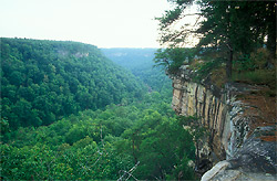
Little River Canyon National Preserve
Little River is the only river in North America that runs
virtually its full course atop a mountain. It forms on top
of Lookout Mountain and reaches its base twenty-four miles
later. Along the way, you can find drops over 600 feet from
the top of sandstone cliffs to the canyon floor.
Little River Canyon is one of the deepest gorges in the
southeast and Little River is one of the wildest and
cleanest rivers in the southeast. After leaving the canyon,
it flows into Weiss Lake and on to the Coosa River. If you
are coming from Fort Payne, the nearest city, take Ala 35 up
and over the mountain until you cross the bridge at Little
River. Here you find Little River Falls which marks
the beginning of the canyon. It is easily accessible with
parking and a restroom. There is a paved walkway to a
platform overlooking the falls. At low water levels visitors
enjoy walking around the dry areas of the river bottom just
above the falls. This is one of Alabama's most scenic
waterfalls.
The calm upper stretches of Little River flow through
forested back-county until they reach Little River Falls.
The river is accessible for swimming or canoeing. Blue Hole
is a popular swimming hole a few hundred yards upstream from
the Little River Falls. There is a little side road to pull
off of Ala 35, to park by Blue Hole.
Below the falls, on the southern end of the preserve, there
are only a few access points to the deep canyon. In the
winter and early spring it offers class III and VI
whitewater for expert kayakers. I once walked down the river
from the falls until I could see the power lines crossing
the canyon at Lynn Overlook. I had hoped to cross the river
and climb up where I had previously found a way down, but
there was no way across the water without risking getting my
camera soaked. A memorable sight along this trip was an
unusually round boulder in the middle of the rapids about
the size of a bus.
After you visit Little River Falls, cross back over the
bridge and turn left onto Ala 176. This is the start of Little
River Canyon Rim Parkway, Alabama's most scenic drive,
which runs along the west rim of Little River Canyon and
ends at Canyon Mouth Park. It features a number of
spectacular overlooks. You find picnic tables and split rail
fences, but some of the more interesting views are along
short trails leading from the maintained overlooks. The main
portion of the parkway is well maintained with winding
curves and each overlook compels you to stop and see if it
is more spectacular than the previous one. If you are
willing to expend the effort to hike down to the bottom, you
will have a better perspective of the view from the top.
After you drive about a mile down the parkway, you come to
Lynn Overlook. If you walk the rim of the canyon back
in the direction you drove, you'll soon find a way to climb
down the bluff to the canyon floor. Few people will want to
take this rough way down, but it is one of the few ways
down. There is no trail and when you get to the bottom you
should find a marker to remind you where to go back up.
There is only one place to climb back out. I have gone alone
into remote areas of the canyon several times, but don't
recommend it. Like many such places in Alabama, there is no
cell phone reception. If you have an accident and can't
climb out, you could be in serious trouble.
Continuing along the canyon rim parkway, just past Lynn
Overlook on the other side of the road from the canyon is Beaver
Pond Trail. This three-quarter mile loop is said to be
popular with bird watchers. It leads to a pond where beavers
have made dams and a variety of birds reside. It is an easy
trail through wooded and open areas.
If you want to take pictures of the canyon, there are a
number of picturesque views along Canyon Rim Drive. However,
bear in mind that you will be covering the same photographic
territory as hundreds of thousands of others before you. I
have noticed that even when out-of-state professional
photographers shoot the canyon, they tend to come away with
the same pictures everyone else does. If you want unique
pictures, make some effort and hike sections of the canyon
floor. In the dry summer there are sections that are easily
accessible. When the water is higher, be prepared to wade
back and forth through water if you plan to go far. During
wetter seasons, much of the canyon is impractical to hike.
Following the canyon rim parkway, not far past Lynn Overlook
you pass over Brooks Branch and there is an unofficial
overlook where three or four cars can park. There is a way
down to the branch and on to the river. After periods of
rain it is a nice place to photograph. The first step down
from the overlook, maybe 10 ft, is the most challenging step
because you have to utilize a tree trunk beside a stone wall
to climb up and down. A nice little waterfall which is just
below the road marks the head. There is no trail. You just
follow Brooks Branch to the river. It isn't far, but getting
there involves climbing around boulders and hopping rocks
across the branch. It is not for everyone, but when water is
flowing it is a pretty area. You should take something to
drink any time you hike into the canyon.
Following along Canyon Rim Parkway, shortly after you pass
Mushroom Rock, which sits in the middle of the road, you
come to a small pull off with a park service sign to Lower
Two Mile Trail. This is a well established trail. It is a
steep .2 mile hike to the bottom and a favorite put-in for
kayakers in the spring. If it is your first time to hike to
the canyon floor, this might be a good choice because of the
short distance.
Continuing along the parkway, after several overlooks you
eventually come to Crows Point. It is one of my
favorites. Down below, Bear Creek Canyon joins
Little River Canyon. You can look across the canyon to
Eberhart Point. Not far past Crows Point is an overlook to Grace's
High Falls, the highest waterfall in Alabama, falling
133 feet. It is a seasonal waterfall, hundreds of yards in
the distance across Bear Creek Canyon. It offers a nice view
in the springtime before foliage blocks the view, but in the
dry summer and fall there is no falling water to see.
If you want to experience the beauty of these falls, you can
hike down into the canyon after spring rains. Few people
attempt this because it is not easy. On my first attempt,
from Little River Canyon up Bear Creek, I eventually reached
water that was too deep to cross. On my next attempt I spent
several hours hiking down Bear Creek Canyon to the falls. I
eventually found a shortcut which can make your trip much
easier. The shortcut along with photos and an account of my
trip are here: Grace's
High Falls.
Further down Canyon Rim Parkway on the other side of Bear
Creek Canyon is Eberhart Point. This overlook has
picnic tables, a rest room and a barbecue grill as well as
some of the canyon's nicest overlooks if you walk down the
paths past the official overlook. A three-quarter-mile trail
leads to the floor of Little River Canyon and is well used.
This is the easiest way to get to the canyon floor. It is
not the most scenic path down but it is wide and well
maintained, suitable for anyone with the will.
Kayakers use Eberhart trail as a take-out or as a put-in.
Downstream is seven or eight miles of long flatwater, broken
up occasionally by class II and III rapids, with one class
IV that can be easily portaged. Along the river an
unmaintained trail leads all the way to Canyon Mouth Park.
It is not well defined and in some places there seems to be
no trail at all. Some of it is fairly rugged hiking and
requires crossing the water. Also, at the bottom of Eberhart
trail, you can walk up Little River to Bear Creek Canyon and
on to Grace's Falls when the water is low enough. The
problem is, when the water is low, the falls aren't very
impressive. In the dry summer you can explore many areas of
Little River Canyon that are impossible during wet seasons.
It is a very different experience at different times.
The best of the Canyon Rim Parkway ends at Eberhart Point.
The lower, CR 275 section of the parkway was once paved, but
is no longer maintained and full of potholes. There are no
major overlooks, however there is Powell Trail a put-in for
a class II canoe trip to Canyon Mouth Park. It is longer
than Eberhart trail and unmaintained, but well used and more
aesthetically pleasing. It is also good for a strenuous six
mile, day long hike to Canyon Mouth Park. Or you could hike
up river from Powell Trail to Eberhart Point. Nowhere in the
canyon are you allowed to stay overnight.
Canyon Mouth Park. After leaving Eberhart Point, you
can avoid CR 275 and still reach Canyon Mouth Park by
waiting and turning left onto CR 127. It will come back into
CR 275 where you will then turn right. This soon brings you
to Johnnies Creek and Johnnies Creek Falls. Going down the
mountain here involves the steepest section of road I've
seen in Alabama.
After Little River flows out of the canyon it passes through
Canyon Mouth Park. This day-use facility at the bottom of
the mountain includes a restroom, running water, picnic
areas with barbecue grills, a beach area and a mile long
trail. This is the place to go when you want to pack a
picnic basket, take the family sunbathing, wading, hiking,
barbecuing and enjoying the outdoors in a park setting.b It
is a popular swimming area and marks the end of the 14,000
acre Little River Canyon Preserve, one of the most
impressive natural wonders of the south.